
Most visitors come to Oaxaca for the mole, the markets, and the magnificent ruins — and rightly so. But just beyond the city’s cobblestone streets lies a world of staggering geological drama: yawning cave mouths, cathedral-like cloud forests, vertigo-inducing cliff edges, and rivers that vanish into the earth. These are the wild landscapes that Oaxacans have lived alongside for millennia — and that adventurous travelers are only beginning to discover. If you’re ready to trade the zócalo for something rawer, this guide is for you.
Why Oaxaca’s Natural Landscapes Are Unlike Anywhere Else in Mexico
Oaxaca is one of the most biologically and geologically diverse states in all of Mexico. The Sierra Madre del Sur cuts dramatically through the territory, creating microclimates that range from semi-arid valleys dotted with cacti to misty cloud forests draped in moss and bromeliads — sometimes within just a few kilometers of each other. This extraordinary variety is not a coincidence. Oaxaca sits at the convergence of several tectonic and ecological zones, a fact that has shaped everything from the region’s karst cave systems to its high-altitude pine-oak forests.
According to data from INEGI, Oaxaca contains more than 570 municipalities — the most of any Mexican state — and a significant portion of its territory falls within protected natural areas. The National Commission of Natural Protected Areas (CONANP) manages several key ecosystems in the region, ensuring that travelers can access these wild places responsibly. For those willing to leave the city for a day, the rewards are extraordinary.

Underground Oaxaca: Caves, Grottos, and Hidden Cenotes
Perhaps the most dramatically hidden of Oaxaca’s wild landscapes are the ones you can’t see from the surface. The state’s limestone and karst geology has produced a remarkable network of caves, grottos, and underground rivers — some discovered only in recent decades.
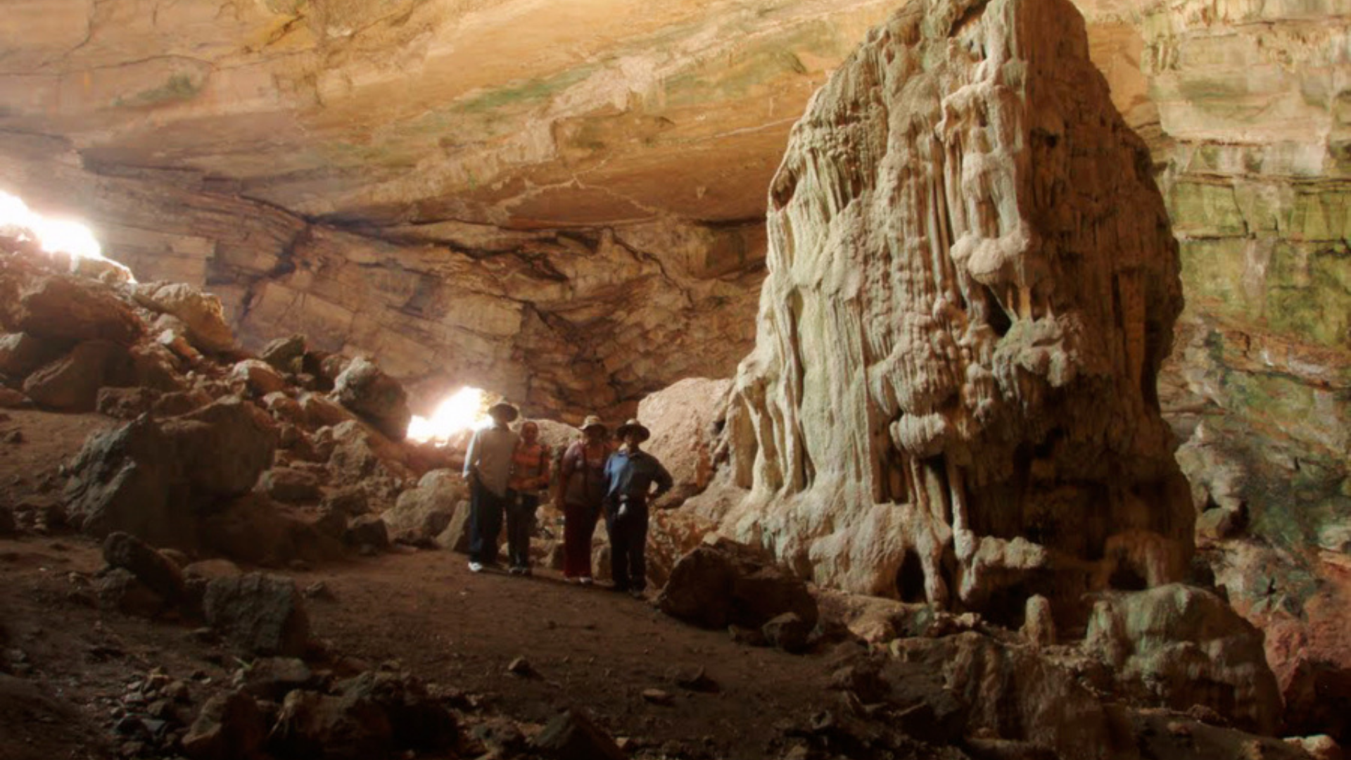
San Sebastián de las Grutas
Located in the Cañada region, roughly two hours from Oaxaca City, San Sebastián de las Grutas is one of the most extraordinary underground experiences in southern Mexico. The site features a series of towering caverns with cathedral-like ceilings, stalactite formations built over millions of years, and — most remarkably — a natural cenote hidden deep within the cave system. The water in this underground pool is calm, crystalline, and untouched by mass tourism. Swimming here feels genuinely otherworldly.
The caves are managed by the local community, which means your visit directly supports indigenous families and sustainable ecotourism. Helmets and headlamps are provided; no prior cave experience is needed.
Santiago Apoala: The Canyon That Swallowed a River
In the Mixteca Alta region, the village of Santiago Apoala sits inside a canyon of sheer white limestone walls, where the Apoala River disappears underground before re-emerging as a series of powerful waterfalls. The Apoala Canyon tour takes you along cliff edges, past petroglyph sites, and to the base of thundering falls that are virtually unknown outside Mexico. In Mixtec cosmology, Apoala is literally the birthplace of humanity — which gives hiking here a dimension that goes far beyond scenery.
Mountain Cliffs and Cloud Forests: The Sierra Juárez
North of Oaxaca City, the Sierra Juárez (officially known as the Sierra Norte) rises steeply from the Central Valleys into one of Mexico’s most pristine mountain ecosystems. These forests — blanketing the highlands of the Zapotec communities — are home to endemic bird species, giant oaks, cloud-forest orchids, and some of the most dramatic cliff-top viewpoints in the country.
The Glass Viewpoint tour in Ixtlán de Juárez brings you to a transparent platform cantilevered over a cliff edge, with a 360-degree panorama of forested ridges dropping thousands of meters into the valleys below. It is, genuinely, one of the most spectacular viewpoints in Mexico. The surrounding trail network passes through old-growth forest where Quetzal sightings — while not guaranteed — are not unheard of during migration season.
What Makes the Sierra Juárez Forests Special
- Biodiversity hotspot: The Sierra Norte sits within one of Mexico’s 35 terrestrial priority regions identified by CONANP, protecting habitats for hundreds of endemic plant and animal species.
- Community-managed ecotourism: Villages like Ixtlán, Benito Juárez, and Lachatao manage their own forests under communal land rights — a rare and effective conservation model.
- Year-round access: Unlike some highland areas, the main trails and viewpoints are accessible in every season, though the dry season (November–May) offers clearer skies and easier road conditions.
- Altitude range: The sierra spans roughly 1,500 to 3,200 meters above sea level, producing wildly varied scenery within a single day’s hiking.
- Endemic wildlife: The Oaxacan Chestnut, the Mountain Trogon, and the Horned Guan are among the species found in these high-altitude forests.
Petrified Waterfalls and Mineral Cliffs: Hierve el Agua
No list of Oaxaca’s wild landscapes would be complete without Hierve el Agua — the iconic mineral springs that have created natural “petrified waterfalls” of calcium carbonate cascading over sheer cliffs. The effect is unlike anything else on the continent: streams of mineral-laden water have flowed over these escarpments for thousands of years, depositing layer upon layer of white and ochre rock that mimics frozen waterfalls.
The Hierve el Agua full-day tour combines this geological wonder with a visit to the Zapotec weaving village of Teotitlán del Valle and a stop at a family-run mezcal distillery — making it one of the most well-rounded day trips from Oaxaca City. Natural infinity pools fed by mineral springs allow you to swim while overlooking the valley below.
San José del Pacífico: Where the Forest Meets the Clouds
Perched at 2,500 meters above sea level in the Sierra Sur, the village of San José del Pacífico is the kind of place that hikers dream about. Dense pine-oak forest, dramatic hanging bridges, and persistent cloud cover give the landscape an almost mythical quality. The air is cool and scented with pine resin; the trails wind through forest that muffles all sound except birdsong and wind.
The San José del Pacífico adventure tour includes a crossing of the famous hanging bridges suspended above forested ravines — a genuine adrenaline moment in an otherwise serene landscape. The views from the ridge, when the clouds lift, stretch all the way to the Pacific coast.
A Traveler’s Story
“I had no idea Oaxaca had places like this. We drove up into the clouds and suddenly we were in this ancient forest with hanging bridges above a ravine. My kids were terrified and thrilled at the same time. When we got back to the city that evening and had mezcal on the terrace, it felt like we’d been gone a week.” — Marcus T., Toronto, Canada
Comparing Oaxaca’s Wild Landscape Experiences
| Destination | Landscape Type | Physical Difficulty | Best Season | Duration from Oaxaca City | Highlight |
|---|---|---|---|---|---|
| San Sebastián de las Grutas | Caves & underground cenote | Low–Moderate | Year-round | ~2 hrs each way | Subterranean swim in crystal water |
| Santiago Apoala | Canyon, cliffs & waterfalls | Moderate | Oct–May (dry) | ~3.5 hrs each way | Mythical Mixtec birthplace site |
| Sierra Juárez / Ixtlán | Cloud forest & cliff viewpoint | Low (viewpoint); Moderate–High (trails) | Nov–May | ~1.5 hrs each way | Glass floor over forested valley |
| Hierve el Agua | Mineral cliffs & springs | Low | Year-round | ~1.5 hrs each way | Infinity pool over the valley |
| San José del Pacífico | Highland forest & bridges | Moderate | Nov–Apr (dry) | ~2.5 hrs each way | Hanging bridges above ravines |
How to Prepare for Oaxaca’s Wild Landscapes
- Layer your clothing: Temperatures at altitude drop sharply — even in summer. Bring a windproof layer and closed-toe shoes even on clear days.
- Hydrate proactively: The dry mountain air and altitude (many sites are above 2,000 m) accelerate dehydration. Carry at least 1.5 liters of water per person.
- Sun protection matters: At altitude, UV exposure is significantly higher than at sea level. Use SPF 50+ and a wide-brimmed hat.
- Respect community rules: Many sites are managed by indigenous communities. Follow local guide instructions, stay on marked paths, and don’t remove natural materials.
- Cash is often required: Several community-run sites do not accept cards. Carry local currency.
- Book guided tours: Many of these locations are difficult to reach independently and are best experienced with knowledgeable local guides who understand the terrain, ecology, and cultural context.
- Check road conditions: Mountain roads in Oaxaca can be affected by rain, fog, or seasonal closures. Always verify conditions before departure — especially in the rainy season (June–September).
Frequently Asked Questions
Are these wild landscapes safe to visit?
Yes — the destinations listed here are established ecotourism sites with community management. Going with a reputable guided tour significantly reduces any risk related to navigation, trail conditions, or wildlife. Always follow your guide’s instructions and stay on designated paths.
What is the best time of year to explore Oaxaca’s natural landscapes?
The dry season — roughly November through April — offers the clearest skies, most stable road conditions, and best access to mountain and cave sites. However, waterfalls like those at Apoala are most dramatic just after the rains (October–November). Hierve el Agua and the caves are accessible year-round.
Do I need special equipment for cave visits or cliff hikes?
For most of the sites listed here, no specialized gear is required. Community guides provide helmets and headlamps for cave visits. Sturdy walking shoes (not sandals) are recommended for all mountain and trail destinations. For the hanging bridges at San José del Pacífico, a basic level of comfort with heights is helpful.
Can I visit multiple wild landscapes in one trip to Oaxaca?
Absolutely — in fact, that’s the ideal approach. A 5–7 day itinerary could comfortably include Hierve el Agua, the Sierra Juárez, San José del Pacífico, and San Sebastián Grutas, with Apoala as a longer adventure day. Each destination is distinctly different, so there is no repetition.
Are these sites appropriate for families with children?
Several are — particularly Hierve el Agua (easy walking, swimming) and the Sierra Juárez Glass Viewpoint (short walking distance, dramatic payoff). San Sebastián Grutas is also suitable for older children. The hanging bridges at San José and the canyon trails at Apoala require a bit more physical confidence.
How do these nature tours support local communities?
Nearly all of the wild landscape sites around Oaxaca are managed under bienes comunales — communal land rights held by indigenous Zapotec and Mixtec communities. Entrance fees, guide services, and tour revenue go directly to local families and fund ongoing conservation. Visiting these places is one of the most direct ways to support rural Oaxacan communities.
For official information on protected natural areas, visit the National Commission for Natural Protected Areas (CONANP) and Oaxaca’s State Tourism Secretariat.
A Final Word on Going Wild in Oaxaca
Oaxaca’s wild landscapes are not a footnote to the cultural experience — they are the cultural experience. The caves, cliffs, forests, and canyons of this region are not separate from Zapotec and Mixtec civilization; they are woven into it. The same mountains that shelter the most biodiverse forests in Mexico are also the same mountains from which indigenous communities have drawn identity, mythology, and sustenance for thousands of years. To explore Oaxaca’s nature is to understand Oaxaca itself. And there has never been a better time to venture beyond the city.
Information may change; please confirm schedules, regulations, and availability before booking. For legal, environmental, or safety matters, consult local authorities or official sources. For more details, visit the Tours Oaxaca MX tour listings or contact us directly.


