
Most travelers come to Oaxaca for its markets, mole, and mezcal — and they leave completely changed by all three.
But the ones who venture north, into the rugged folds of the Sierra Juárez, discover something
even harder to describe: pine forests shrouded in mist, hanging bridges swaying above ravines, Zapotec villages
where life moves at the pace of the mountain wind, and a glass-floored viewpoint that puts you face-to-face with
the void above an endless green valley. This is Oaxaca above the clouds — raw, silent, and absolutely
unforgettable.
What Is the Sierra Juárez and Why Does It Matter?
The Sierra Juárez — also called the Sierra Norte de Oaxaca — is the dramatic mountain
range that rises directly north of Oaxaca City, reaching elevations above 3,000 meters (nearly 10,000 feet).
Named in honor of Benito Juárez, Mexico’s most celebrated indigenous president who was born in the mountain
village of Guelatao, this region is one of the most biodiverse and culturally rich landscapes
in all of Mexico.
The Sierra Juárez is part of the Pueblos Mancomunados, a network of eight Zapotec communities
that have managed their forests communally for centuries. According to
CONANP (Mexico’s National Commission for Protected Natural Areas),
this region forms part of a critical biodiversity corridor connecting tropical lowlands with alpine pine-oak
forests — meaning the ecological variety here is simply extraordinary.
For travelers, it means cloud forest hikes, endemic wildlife, misty mountain vistas, and an authentic
glimpse into Zapotec highland life — all within two to three hours of Oaxaca City.

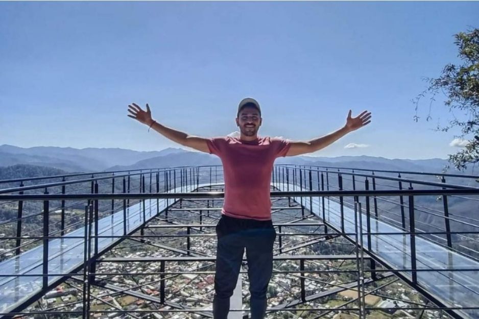
The Crown Jewel: Glass Viewpoint (Mirador de Cristal) at Ixtlán de Juárez
If you only do one thing in the Sierra Juárez, make it the Glass Viewpoint (Mirador de Cristal)
near Ixtlán de Juárez. This remarkable structure extends over a sheer cliff edge, with a
transparent glass floor that lets you look straight down into a valley of pine trees and cloud cover hundreds
of meters below.
The experience is equal parts terrifying and transcendent. On clear mornings, the view stretches across rolling
ridgelines all the way to the Pacific horizon. On foggy days — which are common at altitude — you stand above
the clouds themselves, watching mist drift between the pines below you. Both versions are breathtaking.
Beyond the viewpoint, the Ixtlán de Juárez community ecotourism project includes zip lines,
hanging bridges, mountain bike trails, and guided forest walks managed entirely by local Zapotec families.
This kind of community-owned ecotourism is exactly what responsible travel looks like in practice.
Our guided Glass Viewpoint (Ixtlán) & Mountain Villages (Northern Sierra) tour
takes you into the heart of this landscape with a knowledgeable local guide who knows the road, the history,
and the best spots to stop along the way.
Hiking the Sierra Juárez: What to Expect on the Trails
Hiking in the Sierra Juárez is nothing like trekking on well-groomed tourist trails. These are working
community forests — the paths wind through pine-oak woodland, cross cold mountain streams, and often
emerge onto ridgelines with sweeping 360-degree views. Here’s what the terrain actually looks like:
Forest Types You’ll Walk Through
- Pine-oak forest: The dominant landscape, with towering pines and oaks draped in moss and
bromeliads at higher elevations. - Cloud forest (bosque mesófilo): Dense, humid, and hauntingly beautiful — found in the
transition zones around 2,000–2,500 meters. You’ll often be literally walking through clouds. - Alpine grassland (zacatonal): At the highest ridges, the forest gives way to open meadows
with panoramic views in every direction.
Wildlife to Watch For
- Black-throated jays, resplendent quetzals (seasonal), and dozens of other endemic bird species
- White-tailed deer and coati in the early morning
- Rare orchids, bromeliads, and medicinal plants used by local healers
- Fireflies lighting up the forest floor at dusk in the warmer months
Trail Difficulty Overview
| Trail / Experience | Difficulty | Duration | Best Season | Highlights |
|---|---|---|---|---|
| Glass Viewpoint Walk (Ixtlán) | Easy–Moderate | 1–2 hours | Year-round | Glass floor viewpoint, hanging bridge |
| Cuajimoloyas Forest Loop | Moderate | 3–4 hours | Nov–May | Cloud forest, endemic birds, mountain views |
| Benito Juárez–Lachatao Ridge | Challenging | 5–7 hours | Nov–Apr | Ridgeline views, Zapotec villages, forest diversity |
| Guelatao to Yavesía | Moderate | 3–5 hours | Year-round | Birthplace of Benito Juárez, Enchanted Lagoon |
| Zip-line & Hanging Bridges Circuit | Easy (activity-based) | 2–3 hours | Year-round | Adrenaline, canopy views, family-friendly |
The Villages of the Sierra Juárez: Culture Above the Clouds
The Sierra Juárez isn’t only a natural destination — it’s a living cultural landscape. The mountain
communities here are among the most self-determined indigenous communities in Mexico, managing their forests,
schools, clinics, and governments through traditional usos y costumbres (customary law). Visiting
these villages isn’t tourism in the conventional sense — it’s a window into a way of life that has persisted
for over a thousand years.
Key Villages to Know
-
Ixtlán de Juárez: The gateway town to the Sierra, known for its ecotourism infrastructure,
communal forest management, and the Glass Viewpoint. The community’s forestry enterprise is held up as a
national model for sustainable development. -
Guelatao de Juárez: A tiny, serene village on the banks of the Laguna Encantada
(Enchanted Lagoon) — the birthplace of Benito Juárez and a place of genuine historical significance.
The lagoon itself is said to be bottomless, and the surrounding forest is deeply peaceful. -
Cuajimoloyas: One of the highest villages in Oaxaca state, perched at around 3,000 meters.
Known as the starting point for some of the region’s most challenging cross-country hikes. -
Lachatao: A remote, beautiful village with colonial-era ruins and connections to pre-Hispanic
Zapotec settlements. One of the most atmospheric stops on any multi-day mountain trek. -
Benito Juárez (village): Named after the president, this cloud-forest settlement is often
the first village travelers encounter on guided hikes through the Pueblos Mancomunados network.
When you’re planning your Oaxaca itinerary, combining the Sierra Juárez with other experiences creates a
beautifully balanced trip. Contrast the mountains with the ancient ruins of
Monte Albán and artisan villages,
or the lush highland landscapes with the desert canyons of
Hierve el Agua and Mitla.
For an even more dramatic contrast, follow your mountain days with the warm Pacific at
Puerto Escondido.
Practical Tips for Hiking the Sierra Juárez
What to Pack
- Layers: Temperatures at altitude can drop below 10°C (50°F) even in summer, and cloud
forest is perpetually humid. A waterproof windbreaker is non-negotiable. - Hiking boots: Trails are often muddy, rooted, and uneven. Leave the sneakers for the
city. - Sunscreen and sunglasses: At altitude, UV intensity is significantly higher than at
sea level. - Cash: Most mountain villages have no ATMs. Carry Mexican pesos in small denominations.
- Water and snacks: Hydration is critical at altitude. Bring more than you think you’ll
need. - Camera or binoculars: The birdlife alone is worth it.
- Respect for community rules: Some areas are sacred or restricted. Always follow guide
instructions.
Best Time to Visit the Sierra Juárez
The Sierra Juárez is accessible year-round, but each season offers a different experience:
- November to April (Dry Season): Clearest skies, best visibility from viewpoints, and
lower risk of trail flooding. Ideal for ridge hikes and long-distance walks. - May to October (Rainy Season): The forest is at its most lush and intensely green.
Waterfalls run strong, wildflowers bloom, and the cloud forest is at its most atmospheric. Trails can be
slippery — proper footwear is essential.
According to Oaxaca’s
Secretary of Tourism (SECTUR), the northern mountain communities receive significantly fewer visitors
than the central valleys — which means even in peak season, you’re unlikely to share a trail with crowds.
A Real Traveler’s Experience
“I almost skipped the Sierra Juárez — I thought the ruins and food would be enough. But on our last day,
we did the Glass Viewpoint tour with a guide from Tours Oaxaca MX and it completely changed the trip.
Standing on that glass floor above the clouds, looking down at pine trees disappearing into mist — I
genuinely couldn’t speak for a few minutes. Then we stopped in Guelatao at the lagoon where Benito Juárez
grew up, and I sat there thinking: this is what I came to Mexico for. Not a restaurant, not a ruin. Just
this silence and this view.”— Margot L., traveler from Lyon, France
How to Get There Without a Headache
Driving independently to the Sierra Juárez requires navigating narrow mountain roads with steep drops and
limited signage — and while the scenery is extraordinary, the logistics can be stressful if you’re unfamiliar
with the route. The road from Oaxaca City to Ixtlán de Juárez climbs more than 1,500 meters in under 80
kilometers, with tight switchbacks and occasional road maintenance delays.
For most visitors, the most comfortable and informative option is a guided day tour departing from Oaxaca
City. See our full
Sierra Juárez & Glass Viewpoint day trip
for pickup details, included stops, and everything you need to plan your mountain day.
For those planning a multi-day adventure, consider also exploring
Apoala Falls & Mountains
— another stunning northern Oaxaca destination that pairs beautifully with a Sierra Juárez itinerary.
Frequently Asked Questions About the Sierra Juárez
Is the Sierra Juárez suitable for beginners?
Yes — with the right tour. Activities like the Glass Viewpoint walk, hanging bridge circuit, and community
visits are accessible to most fitness levels. More demanding ridge hikes require moderate fitness and proper
footwear but don’t require mountaineering experience.
How far is the Sierra Juárez from Oaxaca City?
Ixtlán de Juárez, the main gateway town, is approximately 75–80 kilometers from Oaxaca City — about 2 to
2.5 hours by road due to the mountain terrain. Most guided tours depart early morning to maximize time in
the mountains.
Can I visit the Sierra Juárez independently?
Yes, but it requires advance planning. Community tourism cabins and guided services within the Pueblos
Mancomunados must often be booked directly with local cooperatives. The road can be challenging, especially
in the rainy season. A guided tour is the most practical and culturally respectful way to visit for
first-timers.
Is the Glass Viewpoint (Mirador de Cristal) safe?
Yes. The structure is engineered and maintained by the Ixtlán community ecotourism project. That said, if
you have a fear of heights, approach with care — the drop below the glass floor is real and vertiginous.
Most visitors find it exhilarating rather than frightening once they’re on it.
What other Oaxaca tours pair well with the Sierra Juárez?
The Sierra Juárez pairs beautifully with culturally contrasting day trips. Consider combining it with the
Monte Albán & Artisan Villages tour
for an archaeology day, or the
San José del Pacífico & Hanging Bridges adventure
for a second mountain experience on the southern route.
Is it cold in the Sierra Juárez?
Yes — significantly colder than Oaxaca City, which sits at around 1,550 meters. Villages in the Sierra
reach 2,500–3,000 meters, where temperatures regularly drop to 5–10°C (40–50°F), especially in the morning
and after rain. Bring layers regardless of the time of year.
Conclusion: The Mountain Side of Oaxaca Is Waiting
The Sierra Juárez is one of those rare places where nature, culture, and history come together so completely
that the experience becomes hard to compartmentalize. You’re not just hiking — you’re walking through living
Zapotec territory, breathing cloud forest air that indigenous communities have protected for generations,
and standing on a glass edge above a world most people never see. If you’ve been planning your Oaxaca trip
around markets and ruins, this is your invitation to look north. The mountains are calling, and they will
not disappoint.
According to UNESCO,
Oaxaca’s combination of cultural and natural heritage is among the most significant in the Americas. The
Sierra Juárez is a living part of that story — and it belongs on every serious traveler’s Oaxaca itinerary.
Information may change; please confirm schedules, regulations, and availability before booking.
For legal, environmental, or safety matters, consult local authorities or official sources.
Visit our Tours Oaxaca MX homepage
or contact us directly for current tour details and availability.

